United States
›
California
›
Desolation Wilderness
›
Granite Lake via Bayview Trail and Eagle Falls Trail
Search
Search
Granite Lake via Bayview Trail and Eagle Falls Trail
(
)
★
★
★
★
★
based on
5
tracks & routes
|
|
MODERATE
#57
hike out of 279 in
Desolation Wilderness
|
MODERATE
View Photos (332)
fullscreen
link
Copy Link
email
Email
directions
Driving Directions
file_download
GPX/KML
GPX
KML
4.6
mi
Distance
2
hrs
4
min
Time
terrain
1,654
ft
Elev Gain
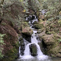
Sights to See
Granite Lake
Public Tracks
neanderbites
3 years, 8 months ago
Eagle Falls Trail to Bay View Trail
Jeff Pollard
9 years ago
Lower Eagle Falls to Inspiration Point, Emerald Bay Vista, CA
Elevation Profile
0
1
2
3
4
7.0k
7.5k
8.0k
Seasonal Popularity
Jan
Feb
Mar
Apr
May
Jun
Jul
Aug
Sep
Oct
Nov
Dec
0k
0.001k
0.002k
0.003k
0.004k
Nearby Hiking Trails
Cathedral Lake via Mount Tallac Trailhead
★
★
★
★
★
MODERATE
7.7
mi
Mount Tallac via Mount Tallac Trailhead
★
★
★
★
★
DIFFICULT
4.5
mi
CA Sec K (Benson Hut)
★
★
★
★
★
DIFFICULT
61.5
mi
Rubicon Hiking Trail, from Eagle Falls Trailhead
★
★
★
★
★
DIFFICULT
11.4
mi
Maggies Peaks via Bayview Trail
★
★
★
★
★
MODERATE
1.9
mi
Eagle Lake via Eagle Falls Trail
★
★
★
★
★
EASY
1.9
mi
Upper Velma Lake from Eagle Falls Trailhead
★
★
★
★
★
MODERATE
3.9
mi
Lower Eagle Falls and Vikingsholm Castle
★
★
★
★
★
EASY
2.7
mi
Mount Tallac via Glen Alpine Trail
★
★
★
★
★
DIFFICULT
11.7
mi
Upper Eagle Point Campground via Rubicon Trail
★
★
★
★
★
EASY
4.6
mi