Pinnacle Mountain - Table Rock Loop, in Table Rock State Park, SC
Overview
This is the premier hike in Table Rock State Park (TRSP), hitting most of the highlights the park has to offer.
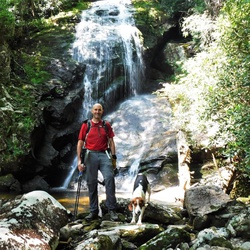
The hike begins at the TRSP Nature Center, and despite being a popular area with tourists, it passes some gorgeous waterfalls and features along Carrick Creek. You will quickly encounter a junction that would take you to Table Rock to the right or Pinnacle Mtn to the left. While you can do either direction, this writeup describes taking the left (clockwise) route toward Pinnacle Mtn.
The first few miles will be a steady climb up to Pinnacle Mtn. You will pass a number of photo-worthy features, including rock outcrops and a delicate waterfall landing directly across the trail. At around 2.5 miles in, you'll pass the trail to Mill Creek Falls on the left, which is an enjoyable side trip to an attractive waterfall.
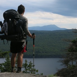
Continue upward to Bald Knob, a rock outcrop that has the best views for the entire Pinnacle Mtn Trail. Above Bald Knob, the remainder of the hike up to the Pinnacle Summit is steep and forested. At the summit, the trail toward Table Rock leads to the right (Northeast).
Follow the ridgeline along this trail for a few miles of pleasant forest hiking. At the junction to return back to the trailhead, bear left toward the Table Rock Summit. There are a few steep climbs and nice views, such as at Governor's Rock. After reaching the summit, continue on the established trail to reach rock overlooks with fantastic long-distance views.
After returning back from the summit, head left at the first trail junction to take the most direct route back to the trailhead. It is mostly downhill from here. At around 2 miles from the trailhead, you will find the "Halfway Shelter".
This trail goes by Bald Knob viewpoint, Pinnacle Mountain, Governor's Rock, Table Rock, view point, trail shelter and view point, Spring Bluff Falls , and Green Creek Falls.
Getting Started
This hike begins at Table Rock State Park Nature Center.
The park requires a fee to leave your vehicle, and there often is not an attendant that can make change. Make sure you bring correct change to cover the people in your vehicle, and consider getting a SC SP annual pass:
https://southcarolinaparks.com/park-passports
Taking Children
The lower parts of this trail are beautiful and well-suited for children. Many school groups visit this area.
Higher up the trail, there are rougher sections of trail, as well as steep cliffsides which are less suited to children and pets.
Rate this Hike
★★★★★


Public Tracks


 stars
stars