meta

Custer Gallatin National Forest Hike

based on 168 tracks & routes
#21 hike out of 148 in
emailEmail directions Driving Directions
3.2 mi
Distance
1 hrs 29 min
Time
terrain
1,358 ft
Elev Gain


Public Tracks

user_profile
michael_h_garrett 3 years, 6 months ago
Gallatin NF: Beehive Basin
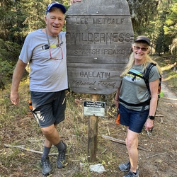
See photo. The sign for the wilderness area is actually about 1/2 mile east of the boundary as shown on Gaia Topo. Not sure which is correct.
user_profile
dr jeff 9 years, 8 months ago
Beehive Basin
Beautiful views and flowers. L Lone Mountain from Marmot Hill. R the Beehive. No snow in the basin end of June. Will be a dry summer
user_profile
a_pinnell 4 months, 3 weeks ago
user_profile
Eric 4 months, 3 weeks ago
user_profile
plbittner 6 months, 3 weeks ago
user_profile
ewaggoner314 3 years, 8 months ago
user_profile
cklock 4 years, 4 months ago
user_profile
kevin.b.palmer 4 years, 5 months ago
user_profile
jons4jc 4 years, 5 months ago
user_profile
jdodge21 4 years, 5 months ago
user_profile
sowinska 4 years, 6 months ago
user_profile
strangetrails 4 years, 6 months ago
user_profile
kirk.lenart 4 years, 6 months ago
user_profile
kirk.lenart 4 years, 6 months ago
user_profile
chinashine1 4 years, 6 months ago
user_profile
Anonymous User 4 years, 7 months ago
user_profile
kyleherdina 4 years, 7 months ago
user_profile
kreide 4 years, 7 months ago
user_profile
matt 4 years, 8 months ago
user_profile
Chrissy 4 years, 8 months ago
user_profile
z_donovan 4 years, 8 months ago
user_profile
Jennie 5 years, 6 months ago
user_profile
David 5 years, 8 months ago