11.5 mi
Distance
4 hrs 48 min
Time
terrain
2,510 ft
Elev Gain
Sights to See
Public Tracks
 stars
stars
Observation Point Trail
Observation Point Trail
I drank 32 ounces water.
On the way up Martha and I spontaneously received multiple compliments and words of encouragement (I assume because of our apparent age). Among them were 2 "Impressive"'s and 2 "You are an inspiration"'s. One very nice couple asked our as he and as he continued down the trail he turned around and said "Nice boots". I had noticed earlier that he was wearing Lowa boots like ours.
The next day on a ranger guided bus tour of the Park our ranger Jason Diger expressed some surprise when we coincidentally mentioned that we had hiked Observation Point Trail the day before.
Today, 9/10/2018, 2 days later, a French couple from Normandy recognized Martha's blue shirt that they remembered from the Observation Point Trail in Zion and said hello.
During the hike I took two doses of ibuprofen, 400 mg each. During the first half of the hike I had some right popliteal pain. The first dose of ibuprofen took care of that. During the second half of the hike I developed right lateral compartment knee pain. I assume the ibuprofen dose helped that some but not completely.
Turns out Observation Point Trail is the most challenging trail at Zion National Park. Longer and more elevation gained than Angel's Landing. See photo taken of the Hiking Guide in the Zion National Park Summer 2018 Map and Guide for comparisons.
I also included a screenshot shot of the Dark Sky app temperature profile for the day showing a high of 84. However Martha points out the car thermometer read 99 degrees F when we returned from the hike.
Total distance hiked 7.69 miles.
Title: Observation Point Trail
Date: 9/8/18, 8:49:54 AM MDT
Distance: 7.69 mi
Time: 07:14:58
Average Speed: 1.1 mph
Max Speed: 5.6 mph
Ascent: 2,213.47 ft
Min/Max Altitude: 4,442.15 ft, 6,521.22 ft
Started: 9/8/18, 8:49:54 AM MDT - (37.27093, -112.93947)
Ended: 9/8/18, 4:04:52 PM MDT - (37.27058, -112.93845)
 stars
stars
Observation Point Trail, Zion NP
Track (10/1/18, 12:06:06PM)
For details of the Observation Point route
https://www.hikingproject.com/trail/7001623/observation-point
Trail is 3.3 miles each way = 6.7 miles total. 12% average grade.
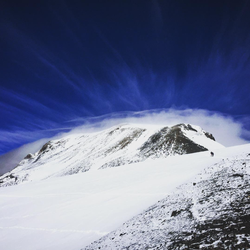
Starting from the Weeping Rock Trailhead take Weeping Rock Trail heading south, then make a right to join East Rim Trail. From here, East Rim heads straight up a slot in Zion Canyon, directly across from Angel's Landing, so the views are spectacular.
Continue up the canyon, past Hidden Canyon Trail on your right, and all the way to an intersection with East Mesa Trail. All the while ascending some incredibly steep switchbacks with little to no respite from the sun.
Once at the intersection with East Mesa Trail, turn left. Starting from East Rim Trail, East Mesa climbs very steeply, switchbacking multiple times until it eventually contours south of a small mesa. Once the trail levels off, all of the hard stuff is done.
After contouring along this smaller mesa, head left onto Observation Point Trail. The trail works its way out to the edge of the canyon rim and offers absolutely astounding panoramic views of the canyon. You'll have clear views of Angel's Landing to the southwest, while the Great White Throne will be in sight due south.
stars
Observation Point out & back- Zion NP
Moderate to Hard hike on a clear and cool day under sunny skies. We planned to hike the Hidden Canyon trail as well, but it has been closed since July 2018 due to rocks slide.

Track (4/16/18, 1:57:57PM) Observation Point from Weeping Rock
Out and Back to Observation Point via East Rim & East Mesa Trails.


 stars
stars


 stars
stars


 stars
stars